The Mosquito Lagoon and the Original Mosquito County
Brevard County was carved out of Mosquito County in 1855. The Mosquito Lagoon at the north end of the Indian River system kept the name even after the county was renamed twice.
Brevard County was carved out of St. Lucie County in 1857, and St. Lucie County was carved out of Orange County in 1855, and Orange County had been called Mosquito County until 1845, and Mosquito County had been created in 1824 as one of the original Florida territorial counties. That direct genealogical line connects modern Brevard to a county named for the bug that kept the lagoon coast nearly unsettled for three centuries.
The 1824 territorial act
The Florida Legislative Council, the governing body of the Florida Territory from 1822 to statehood in 1845, created Mosquito County by act on December 29, 1824. The new county absorbed the southern half of what had been St. Johns County (Florida’s first territorial county, dating to 1821). The boundaries ran from roughly Volusia north to the Caloosahatchee River south, and from the Atlantic to a vague western line near the Withlacoochee.
That was an enormous territory. By comparison, modern Brevard, Indian River, Martin, Palm Beach, Broward, Miami-Dade, and most of Osceola, Orange, Lake, and Polk all fit inside the 1824 Mosquito County boundaries. The territory contained perhaps 200 to 400 non-Indigenous residents total, mostly concentrated near New Smyrna and a few smaller settlements.
Why “Mosquito”?
The name came from the Mosquito Inlet (now called Ponce de Leon Inlet), the natural pass between the Atlantic and the Mosquito Lagoon at the north end of the Indian River system. The inlet had been named “Boca de los Mosquitos” by Spanish navigators as early as the 1600s, in reference to the dense salt-marsh mosquito populations that bred in the surrounding mangroves and tidal flats.
The 1824 territorial act adopted the Spanish-derived name. The Mosquito Inlet, the Mosquito Lagoon, the Mosquito River (now the Halifax River north of the inlet), and Mosquito County were all named in honor of the local Aedes and Anopheles populations.
The name was a problem for land sales. Florida was actively trying to attract northern settlement through the 1820s-1840s, and “Mosquito County” was bad branding for the recruitment effort. Land speculators, plantation owners, and would-be settlers regularly complained that the name implied uninhabitability, somewhat accurately, since malaria and yellow fever were both serious endemic problems along the Florida east coast through the 19th century.
The 1845 renaming to Orange County
Florida became the 27th state on March 3, 1845. The new state legislature, meeting in Tallahassee, immediately confronted the Mosquito County branding problem. On December 29, 1845, almost exactly 21 years after the original creation act, the legislature renamed Mosquito County to “Orange County,” in reference to the citrus groves then expanding around present-day Orlando and the Indian River.
The Orange County name was a marketing move. There were citrus groves in the county, but the dominant economic activities were still cattle ranching, subsistence farming, and a small amount of timber. The renaming was approved by an Orange County citizens’ petition and processed by the legislature as a routine administrative act.
Orange County was still enormous in 1845. The boundaries were essentially unchanged from 1824, encompassing roughly 11,000 square miles of Florida territory. The county seat moved from Enterprise (on Lake Monroe, near today’s Sanford) to Mellonville (also on Lake Monroe), and eventually to Orlando in 1856.
The 1855 split, Brevard’s direct origin
The Florida General Assembly, by act of January 6, 1855, carved the eastern coastal strip out of Orange County and created “St. Lucie County.” The new county ran along the Atlantic coast from the southern boundary of Volusia south to a line near present-day Stuart, and inland to a line east of the Kissimmee River. The county seat was at Susannah, a small settlement near St. Lucie Inlet.
The 1855 split happened because the coastal Atlantic settlements were tired of traveling inland to Orlando for county business. The settlers near Cocoa, Rockledge, and Eau Gallie wanted local courts and local government, which required a coastal county seat. Susannah was geographically central to the new St. Lucie County’s elongated shape but was not particularly close to the population center, which was clustered around Cocoa-Rockledge.
Two years later, on January 6, 1857, the legislature renamed St. Lucie County to Brevard County, in honor of state comptroller Theodore Brevard, and moved the county seat northward. The Mosquito County → Orange County → St. Lucie County → Brevard County lineage took 33 years and four legislative acts to complete.
What the Mosquito Lagoon retained
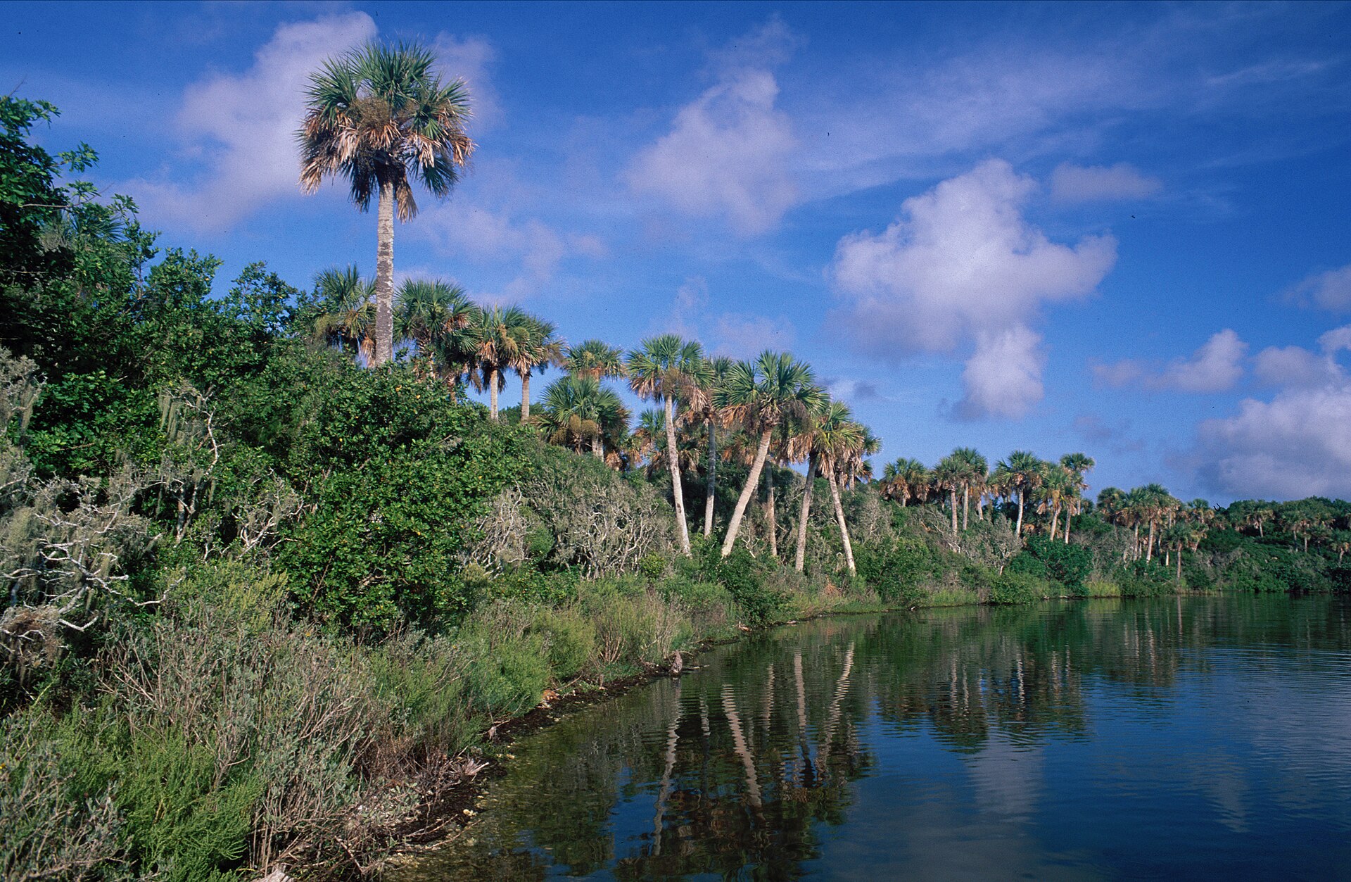
The county-name changes did not change the lagoon name. The Mosquito Lagoon at the north end of the Indian River system kept its name through all four county-name changes, the territorial-to-state transition in 1845, the various boundary realignments, and the eventual creation of Canaveral National Seashore in 1975. The lagoon is still called the Mosquito Lagoon today.
The Mosquito Lagoon is a brackish water body of approximately 38 square miles, separated from the Atlantic by a barrier-island chain that includes Cape Canaveral National Seashore at the south end and stretches north to Ponce Inlet. The lagoon connects to the Indian River through the Haulover Canal (dredged 1854, enlarged in stages through the 20th century) and to the Atlantic through Ponce Inlet at the north end.
The lagoon today is one of the cleaner sections of the broader Indian River Lagoon system, partly because it has the most direct ocean connection (through Ponce Inlet) and partly because it lies almost entirely within Canaveral National Seashore and the Merritt Island National Wildlife Refuge, which limits adjacent development. The Mosquito Lagoon is currently the only section of the IRL system with seagrass populations that have not collapsed in the 2010s-2020s decline.
Why the lagoon kept the name
Place names attached to specific physical features tend to survive political reorganizations because they’re embedded in the regional vocabulary at the user level. Fishermen, boaters, hunters, surveyors, mapmakers, everyone who works the water needs unambiguous names. “Mosquito Lagoon” was unambiguous and unmistakably referred to the specific water body. Changing it would have caused immediate operational confusion. The county name, by contrast, was political administration that could be changed by legislative act without any operational consequence.
The Indian River, the Banana River, the St. Johns River, Lake Okeechobee, the Everglades, the Caloosahatchee, all of these names survived multiple Florida county boundary changes since 1824. Counties are political. Watersheds are not.
What the Mosquito Lagoon means today
For modern Brevard residents the Mosquito Lagoon is primarily a recreational fishing and wildlife area. The lagoon hosts substantial populations of red drum (redfish), seatrout, snook, and tarpon. Charter fishing operations out of New Smyrna Beach, Edgewater, Oak Hill, and the north end of Mims work the lagoon year-round.
Canaveral National Seashore, established 1975, protects approximately 24 miles of barrier-island coastline including most of the Mosquito Lagoon’s eastern shore. The Merritt Island National Wildlife Refuge, established 1963, protects the western shore of the lagoon south of Oak Hill.
The mosquito populations the original county name commemorated are still there, particularly during the wet season. Modern mosquito control districts (the Brevard Mosquito Control District, the Volusia Mosquito Control District) work the lagoon area with both larvicide application and water-management modifications. Endemic malaria has been gone from Florida since the 1940s, but the salt-marsh mosquito populations the early settlers complained about are essentially unchanged in numerical terms.
The Mosquito Lagoon is the last place in the Old Space Coast region where the name of the county that birthed Brevard still applies to the geography. Every other Mosquito County reference has been administratively erased. The water that kept the name is the only durable artifact of a place that was once governed under that label.
Further Reading
As an Amazon Associate we earn from qualifying purchases.