How Brevard County Got Its Name (1855)
Brevard County was carved out of Mosquito County in 1855 and named for Theodore Washington Brevard, then state comptroller. The original boundaries reached as far south as Lake Okeechobee.
Brevard County is named after Theodore Washington Brevard, a North Carolina-born lawyer who served as Florida’s state comptroller from 1853 to 1861. The county was created on January 6, 1855, by act of the Florida General Assembly, carved out of the older Mosquito County. Brevard himself never set foot in the place that took his name. He worked in Tallahassee.
That is the answer in two sentences. The full story has more shape.
Mosquito County, the parent
Before 1855, what is now Brevard was the eastern half of Mosquito County, a single sprawling unit that ran from roughly New Smyrna south to Cape Sable and across to the Gulf coast at points. Mosquito County had been created in 1824 during the Territorial period and named for the Mosquito Lagoon, the brackish strip of water just south of present-day Daytona Beach. The name was descriptive. The Florida General Assembly renamed it “Orange County” in 1845, the same year Florida became a state, on the reasonable grounds that “mosquito” was bad for land sales.
Orange County in 1845 was enormous. It covered everything from Volusia south to roughly the Caloosahatchee, including the entire Indian River coast. As settlement on the Atlantic side ticked up through the 1840s and 1850s, splitting that vast eastern strip into a separate county made sense administratively. Coastal settlers had to travel inland to Orlando or farther to record deeds, file suits, and pay taxes. A county seat on the coast would shorten the trip.
The General Assembly carved out the Atlantic-coast strip on January 6, 1855, named it St. Lucie County, and set the county seat at Susannah on the Indian River. The original St. Lucie County included all of present-day Brevard, Indian River, and Martin counties, plus part of what is now Volusia and Osceola. The county seat at Susannah, near today’s St. Lucie Inlet, was an awkward choice, far south of the population center, which was clustering around the Cocoa-Rockledge area.
So the legislature renamed and reshaped the county within two years.
The 1855 act of January 6, what it actually said
The act creating “St. Lucie County” appears in the Acts and Resolutions of the General Assembly of Florida, Sixth Session, 1854-55. It described boundaries running from the southern boundary of Volusia County south to a line near present-day Stuart, and inland to a line east of the Kissimmee River. The county was named for the Spanish-era “St. Lucia” name for the inlet near present-day Fort Pierce. The county seat was provisionally set at Susannah, a settlement near St. Lucie Inlet that no longer exists.
Two years later, on January 6, 1857, the legislature renamed St. Lucie County to “Brevard County” and moved the county seat northward, eventually settling at Lake Worth, then Susannah again, then finally Titusville in 1879. The 1857 renaming honored Theodore Brevard, the sitting state comptroller.
The legislative record is thin on why Brevard specifically. Allen Morris’s Florida Handbook, the standard reference on Florida political nomenclature, notes Brevard was politically influential, well-liked in Tallahassee, and a useful person for an emerging frontier county to flatter. He helped settle the Florida state debt, which gave him a constituency among bondholders that included plantation owners and developers with land interests on the coast. Naming a county for the comptroller during a period of state-financed land surveys and military road construction was not a coincidence.
Theodore Brevard, briefly
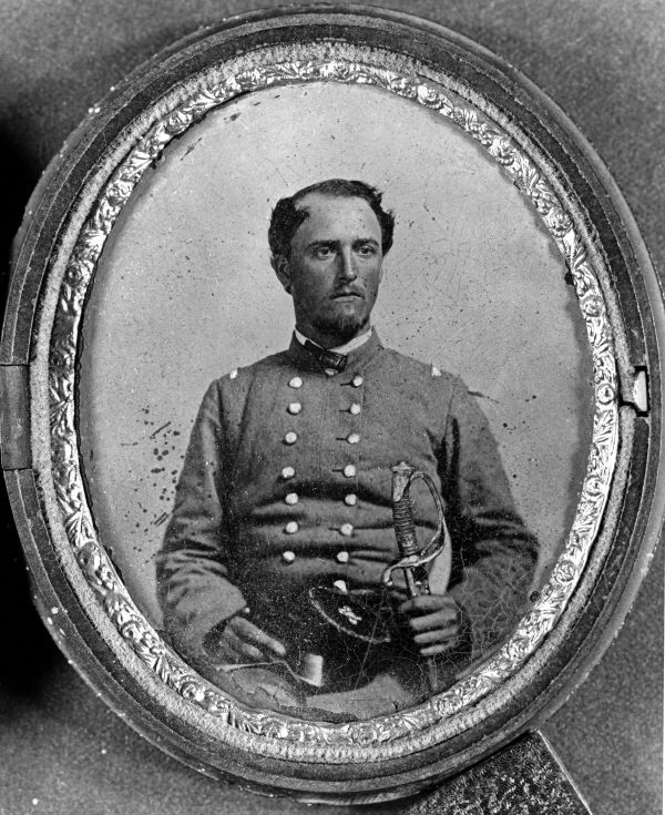
Theodore Washington Brevard was born in Iredell County, North Carolina, on August 25, 1804. He studied law, married Caroline Mays of Tuscaloosa, Alabama, and migrated to Florida in the 1840s as part of the broader southern lawyer-planter class that filled Florida’s first generation of state government. He served two terms as state comptroller (1853-1861), oversaw Confederate finance in Florida during the early Civil War, and died in Tallahassee on May 19, 1877.
His son, Theodore W. Brevard Jr., served as a Confederate brigadier general and is sometimes confused with the father in older sources.
The father never visited the county that bears his name. He had no business interests on the Indian River, no family connections to coastal settlers. The naming was political tribute, the same kind of gesture that produced Marion County (Francis Marion, the Revolutionary War general), Calhoun County (John C. Calhoun, never a Florida resident), and a handful of other Florida counties named for politically useful out-of-state figures.
Boundary changes since 1855
The boundaries of Brevard moved repeatedly through the late 19th century. Major events:
- 1887: Dade County (then much larger than today’s Miami-Dade) is carved out of southern Brevard, removing roughly half the territory.
- 1905: Osceola County takes a slice of western Brevard.
- 1925: Indian River County is split off the southern end, removing what is now Vero Beach, Sebastian, and Fellsmere.
- 1925, same year: Okeechobee County takes a small western strip.
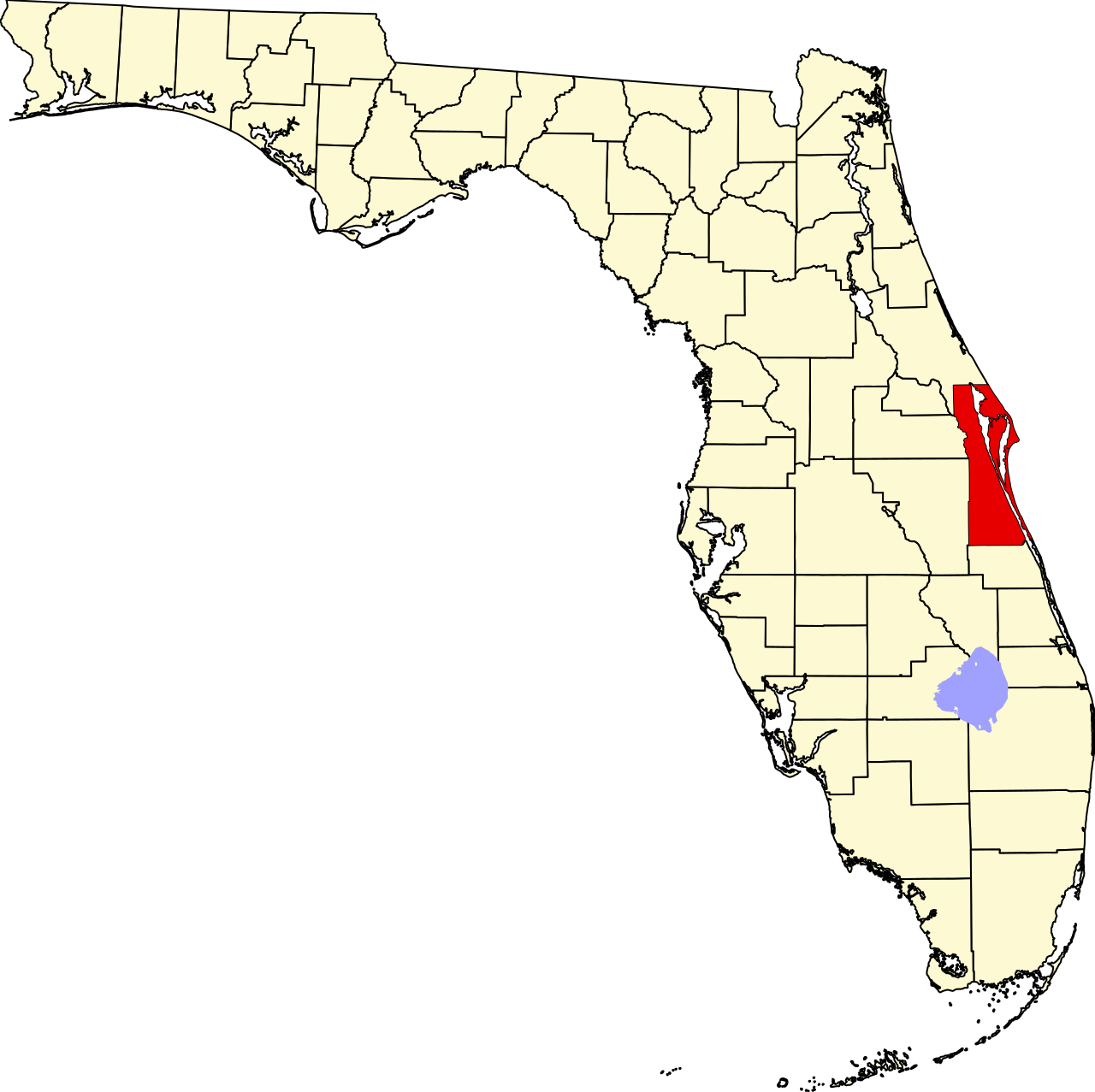
After 1925, Brevard County reached its modern shape: a coastal county running about 72 miles north-south, narrow east-west, hemmed in by the Indian River Lagoon on the east and the headwaters of the St. Johns River drainage on the west.
The county seat moved as the population shifted. The early county seat was at LaGrange, a small settlement near today’s Mims, from 1855 until 1879. In 1879 the legislature moved it to Titusville, which had become the railroad terminus and trading hub for the Indian River steamboat fleet. Titusville has been the seat ever since, though there have been periodic political movements out of Cocoa, Rockledge, and Melbourne to relocate it. None succeeded.
What the name carries
Most American counties named for politicians end up with no surviving connection to the namesake. Brevard is no exception. There is no Brevard family in modern Brevard County of any documented descent. There is no Brevard Hall, no Brevard Memorial. The name is administrative, inherited, unsentimental.
What the county does carry from its origins is the geography of being a strip along a lagoon. Mosquito County was named for what was actually in the water. St. Lucie County was named for the inlet. Brevard County is the name that stuck, but the place is still the lagoon coast, and the lagoon is still the only reason there is a county here at all. The county shape today, narrow north-south along the Indian River, is the same shape it was when settlers in 1855 wanted shorter trips to record their deeds.
Mosquito County, the longer view
The Mosquito County the 1855 act dismantled had its own substantial history. Created on December 29, 1824 as a split from St. Johns County during the Florida Territorial period, Mosquito County stretched 220 miles north to south and 90 miles east to west, encompassing what is now Volusia, Brevard, Indian River, St. Lucie, Marion, Martin, Seminole, Osceola, Orange, Lake, Polk, and Palm Beach counties. It was one of the largest counties in American history by land area at the time of its creation. The 1830 census recorded just 15 heads of household and 733 total persons, most of them enslaved, for the entire territory.
The seat of Mosquito County moved three times before its dissolution. From 1824 to 1835 it sat at John Bunch’s house near present-day Ormond, west of today’s Tomoka State Park. From 1835 to 1843 it was at New Smyrna. From 1843 to 1844 it was at Enterprise, on the north shore of Lake Monroe. The Florida General Assembly disestablished Mosquito County on March 14, 1844, splitting it into Orange County to the north and St. Lucie County to the south. The 1855 St. Lucie-to-Brevard renaming was the second step of that dismantlement, not the first.
The “Mosquito” name itself was older than the county and survived its administrative end. The Spanish records from the 1500s through the British transfer of 1763 used “Los Musquitos” for the entire east coast of central Florida. The Mosquito Lagoon at the north end of present-day Brevard still carries the name. Mosquito Inlet, the original Spanish-era name for what is now Ponce de Leon Inlet at the mouth of the Halifax River, kept the name until the late 19th century. The 1844 county rename was a marketing decision, not an etymology change.
The St. Lucie interim
The St. Lucie County that existed from 1844 to 1855 deserves its own footnote. It carried the name of a Spanish-era inlet, was administered from Susannah near today’s Fort Pierce, and never had a courthouse of any substance built. Population in 1850 was under 200 people across the entire territory. The county records from this 11-year window are thin, mostly land transfers and a small number of probate filings, and they sit in the Florida State Archives at Tallahassee rather than at any modern county courthouse.
The 1855 Brevard rename did not technically create a new county. It renamed the existing St. Lucie County and adjusted some boundaries northward. The legislative record uses the phrase “the county heretofore known as St. Lucie shall hereafter be known and designated as Brevard County.” That language matters for property-title history. A deed recorded at Susannah in 1850 under St. Lucie County is still a valid Brevard County deed because the administrative continuity carried through. Modern Brevard property records back to 1844 are usable; pre-1844 records require working through the Mosquito County rolls held at the state archives.
The current St. Lucie County, the one centered on Fort Pierce, was created in 1905 by carving off the southern end of Brevard. The name was reused because the Spanish-era inlet was still the most recognizable geographic feature in that area. Two Florida counties have now carried the “St. Lucie” name, one from 1844 to 1855, the other from 1905 to today, with a fifty-year gap in between.
Further Reading
As an Amazon Associate we earn from qualifying purchases.